There are many reminders of our ancestors lives and activities that remain in the countryside around us. This might be the pattern of lanes and footpaths still in use, or field boundaries unchanged for centuries.
However, there are also more subtle hints that only become visible under certain conditions – one such example is known as ‘ridge and furrow’, a remnant of an ancient type of ploughing that began in the post-Roman period and in some places, continued up to the 17th century. Under normal conditions, it’s easy to miss the signs, but they become apparent when the sun is low, there has been a scattering of snow, or even (as here) when our recent flood waters receded. It was then that a distinctive pattern of little valleys and ridges re-emerged from the ground.
These distinctive patterns are less common that they once were, as many were destroyed by deep ploughing during the Second World War, when every strip of usable land was turned over to food production. However, Eastington has a number of places where the ridge and furrow pattern still survives – a prime example can be seen in the fields bordering the River Frome as it wends it way downstream from Beards Mill towards Millend. As we all know, these flood regularly, and this is probably why they’ve survived relatively unscathed. As the floods gradually drain away, the patterns in the ground once again became visible (Picture 1). Picture 2 is an aerial view from dryer times, where the various patterns of ridge and furrow are clearly visible.

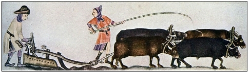
But how were these ripples in the land actually formed? Unlike farming today, throughout the Middle Ages, large open fields were often held in common and were split up into long strips that were ‘farmed’ by different families. These could be retained by the same family over many generations. Although they could vary in length, strips were traditionally a furlong (or a ‘furrow-long’) in length – usually about 200 metres. Ridge and furrow patterns were created by the repeated use of simple one-sided ploughs in use at the time. The plough’s blade cut through the soil, forcing it against a board – this turned it over and moved it sideways . When the oxen reached the end of the strip, they were turned round and the plough pulled in the reverse direction. This gradually pushed soil towards the middle, slowly building up a series of central raised strips (ridges), with small valleys (furrows) between them. This process actually provided some advantages as it effectively increased the surface area, and also encouraged water to drain into the furrows. The wetter furrows proved to be better suited to growing crops such as oats, barley, peas and beans. Wheat might be grown along the ridges.
Over many seasons, and indeed centuries, the ridges got higher and the furrows deeper, but since the end of this type of ploughing perhaps four centuries or more ago, the weather has slowly flattened them. However, the remnants of many are still there, a largely forgotten reminder of our forefathers’ very different way of life, one that was governed not by the clock, but by the seasons, the weather, and how well the year’s crops had grown. Although we might consider traces of this ancient way of farming to be an interesting side line in history, to the families working the land in this way, they could literally mean the difference between life and death.
The headline picture shows ploughing with oxen in the 1300s,as illustrated in the Luttrell Psalter.
Stephen Mills
You must be logged in to post a comment.